Real Time Data, Latest 'Fax' Charts, Latest Model Output, Latest Local Data - All This And More!- Please Explore And Enjoy!
WELCOME TO PETERBOROUGH WEATHER WATCH

Thank you for visiting my site, peterboroughweatherwatch.com, the website of choice for up to date local weather conditions. To find out a bit more about the site and its creator, click here. Please explore and enjoy !! All feedback is welcomed at peterboroughweatherwatch - This site is best viewed in FireFox. Please let me know if you see any display issues and I will fix them.


Thank You For Visiting PeterboroughWeatherWatch - I Hope You Like What You See. Please Drop By Again!


1ST MARCH:

1st March is the start of Meteorological Spring and ends on the last day of May

6TH NOVEMBER 2021:

Added 'accordian' style frames for this and forecast panels to give a less busy look of the page when first landing on it

26TH JUNE 2021:

Unfortunately relocated from Park Farm to Orton Malborne. (About 3miles West of Park Farm).

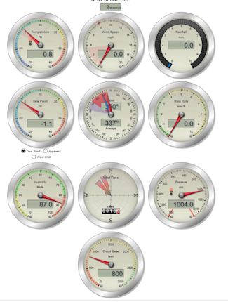
My rain gauge cannot be ideally sited is in a substantial rain shadow, so am under reading rainfall, particularly when rain is coming from the S/W/N. Unfortunately I cannot site my anemometer, so there is no wind data.

If you find my website useful and would like to show your support, click the button. Many Thanks!!


CURRENT CONDITIONS DASHBOARD - Updated

CURRENT WEATHER* :-

* Current Conditions may reflect 'Dry'/'Stopped Raining' when it is obviously raining. Unless rainfall is moderate/heavy during any rainfall, it can take a while for even as little as 0.1mm to be recorded, hence, the perceived 'incorrect' description of 'Dry'/'Stopped Raining'


Hi: at
Lo: at
Hum
Dew
Wetbulb
%
Gusting At
Average
NA
NA
NA
Pressure
Rainfall
Last Hr:

* Unfortunately I cannot site my Anemometer, therefore there is no wind data *

* Unfortunately, with the Sun's increasingly higher elevation, I am again over-reading temperatures under sunny skies, through the morning after 09:00 until around 13:00. I could be over-reading between the times up to 3°C - I will attempt to rectify this over the coming weeks although I cannot re-site my 'Stevenson' Screen *

PETERBOROUGH WEATHER WATCH DAILY FORECAST
For Hourly Local Conditions and Weather Updates through the day
The forecast region is roughly an area within a 25 mile radius of Peterborough City Centre. All forecasts are independently produced by, and are, © peterboroughweatherwatch.

* JUNE 1ST IS THE START OF METEOROLOGICAL SUMMER AND ENDS 31ST AUGUST *

Sunrise 04:41 * Sunset 21:19

FORECAST SUMMARY

Cool/Bright Start - Bright Spells - Risk Of Showers


The expected relatively cool and bright start across the forecast area. Bright spells continue through the morning, although a small trough to the WNW already pushing some cloud across the forecast area as I write, and also brings the risk of some showers, particularly to the NW/N of the area. Bright spells and the continued risk of showers into and through the afternoon.

Temperatures peaking at 15°C or 16°C

WIND:-

Becoming a tad breezy at times in places. Initially from the WSW, veering WNW through the day.


JUNE(2006-23)
MeanMax

16.8°C

MeanMin

8.2°C

MonthMean

13.0°C

Rain

51.9mm

ON THIS DAY LAST YEAR
 
THIS DAY HIGH AND LOW - (Since 2006)
Max Temp

15.1°C

Min Temp

11.4°C

 
2010

26.7°C

2012
4.7°C
POLLEN & UV FORECASTS
POLLEN MODERATE
ULTRA VIOLET
HIGH 6


Bright spells with the continued risk of a shower in places. Variale cloud through the evening, along with some clearer spells, but an ever present risk of a shower. The variable cloud and shower risk theme continues into and through the early hours, and perhaps an area of more organisd showers feeding across the forecast area by/soon after sunrise.

Temperatures falling to 7°C or 8°C

WIND:-

Generally light and mainly from the WSW


Sunrise 04:41 * Sunset 21:19


Bright spells and a risk of some showers looks the theme for Thursday

Temperatures peaking at 16°C

WIND:-

A gentle breeze and mainly from the W/WNW


POLLEN & UV FORECASTS
POLLEN MODERATE
ULTRA VIOLET
HIGH 6


FURTHER OUTLOOK


Site Feedback. Please send any feedback by emailing me at the address under The 'Contact' menu option

* NEED TO FIND A NEW SOURCE FOR THE IMAGE *

* NEED TO FIND A NEW SOURCE FOR THE IMAGE *

Hurricane Watch


Latest M4.5+ Earthquakes