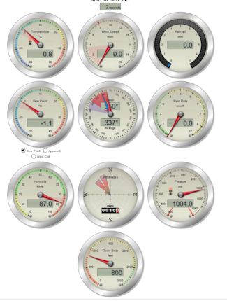
Sunrise 05:21 * Sunset 20:53
* 1ST OF JUNE WAS THE START OF METEOROLOGICAL SUMMER AND ENDS 31ST AUGUST *
FORECAST SUMMARY
Hazy Sunny/Bright Skies - Very Warm/Hot
Looking set to be a hazy sunny skies theme through the morning.. The hazy sunny/bright spells theme continues into and through the afternoon, .
Temperatures in the very warm/hot category, peaking in the 24°C or 26°C range.
WIND:-
A gentle breeze through the morning, increasing through the afternoon. Mainly from the NE
AUG(2006-25) |
MeanMax |
|
MeanMin |
|
MonthMean |
|
Rain |
|
ON THIS DAY LAST YEAR |
|
THIS DAY HIGH AND LOW - (Since 2006) |
Max Temp |
|
Min Temp |
|
|
2018 |
|
2016 |
10.1°C |
.
Hazy bright/sunny spells into and through the early evening. Variable hight cloud through the evening, into and through the early hours, perhaps a very low risk of a shower in places, to the W/NW of the forecast area.
Temperatures falling to 16°C
WIND:-
Falling to a gentle breeze and mainly from the ENE
Sunrise 05:22 * Sunset 20:51
* @08:50 WILL BE PUBLISHED LATER TODAY AFTER 17:00 *
WIND:-