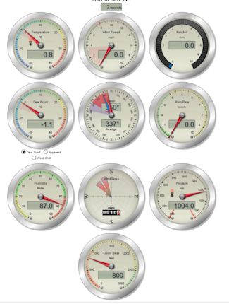
Thank you for visiting my site, peterboroughweatherwatch.com, the website of choice for up to date local weather conditions. To find out a bit more about the site and its creator, click here. Please explore and enjoy !! All feedback is welcomed at peterboroughweatherwatch - This site is best viewed in FireFox. Please let me know if you see any display issues and I will fix them.
SITE NEWS
1ST MARCH
1st March is the first day of Meteorological Spring and ends on 31st May, with Meteorological Summer commencing 1st June
10th FEBRUARY
It is with a very heavy heart, and I was hoping things wouldn't come to this, however I have to advise that due to my current personal circumstances/situation, updates to this website, ie, the 'live' current conditions and daily forecasts, are almost certainly going come an abrupt end with little or no notice and quite possibly within the next 14 days.
Apologies. Anemometer siting remains too low, therefore readings at higher values can be 75%+ under what they should be. Direction info can also be inaccurate due to buildings distorting the wind flow.
CURRENT WEATHER* :-
ANEMOMETER - SITING ISSUES MEAN THAT WIND SPEED/GUST DATA READINGS CAN BE WELL OVER 100% UNDER READING
Hi:6.0°C at 1:52pm |
Lo:3.7°C at 6:59am |
Hum |
Dew |
Wetbulb |
82%
![]() | 0.9°C |
2.6°C |
Gusting At |
Average |
||
0.0 |
3.1 | ||
NNW(346) |
|||
Pressure |
1026.0 hPa |
Steady |
Rainfall |
5.9 mm |
Last Hr:4.4 mm |
PETERBOROUGH WEATHER WATCH - PUBLISHED WEDNESDAY 10TH FEBRUARY
It is with a very heavy heart, and I was hoping things wouldn't come to this, however I have to advise that due to my current personal circumstances/situation, updates to this website, ie, the 'live' current conditions and daily forecasts, are almost certainly going come an abrupt end with little or no notice and quite possibly within the next 14 days.
Sunrise 05:44 Sunset 17:43
FORECAST SUMMARY
Mist/Murk - Risk Of Showers - Perhaps Some Brighter Spells
* APOLOGIES FOR CONTINUED LATE UPDATES *
* APOLOGIES FOR THE VERY LATE UPDATE *
Another misty/murky start across the forecast area. Mist/murk gradually thinning and lifting perhaps to allow some brighter spells to develop through the day, but the risk of some showers pushing across the forecast area into/through the afternoon
Temperatures peaking in the 5°C to 7°C
WIND:
Light and mainly from the ENE/NE
Cloudy with the threat of some showery rain across the forecast area for a time as a shallow area of Low Pressure throws an Occluded Front towards the area from the South. Likely turning misty later through the early hours.
Temperatures falling to 3°C
WIND:
Mainly light, although maybe a tad breezy in places for a time. Mainly from the NNE/NE
Sunrise 05:42 Sunset 17:45
Cloudy, perhaps some early showery rain clearing away SE. Cloudy through the morning/into the afternoon. Perhaps some showers through the afternoon as a weakening/decaying Cold Front crosses the forecast area from the NE. Temperatures peakling at 7°C
WIND:
Mainly light, but likely a tad more of a breeze than past few days. Mainly from the NNE/NE
FURTHER OUTLOOK:- PUBLISHED @
03-03-2021 18:24:08 Mag:5.1 11 km NNE of Grizáno, Greece |
03-03-2021 13:54:03 Mag:4.6 95 km SE of Sand Point, Alaska |
03-03-2021 13:09:22 Mag:5 Lomonosov Ridge |
03-03-2021 11:45:46 Mag:5.3 6 km WSW of Týrnavos, Greece |
03-03-2021 11:35:57 Mag:4.9 8 km SW of Týrnavos, Greece |
* Current Conditions may reflect 'Dry'/'Stopped Raining' when it is obviously raining. Unless rainfall is moderate/heavy during any rainfall, it can take a while for even as little as 0.1mm to be recorded, hence, the perceived 'incorrect' description of 'Dry'/'Stopped Raining'